
Uncrewed Aerial Systems (UAS), commonly known as drones, play a crucial role in supporting OSMRE’s mission under the Surface Mining Control and Reclamation Act (SMCRA) by enhancing operations on both regulatory and abandoned mine land sites. UAS safely and efficiently allow mine inspectors to view entire permit areas without relying solely on satellite data, visual inspection, or ground-based photography. Technical staff from OSMRE, states, and Tribes also use these systems for more advanced surveying and remote sensing workflows, such as thermal imaging of mine fires, contour mapping, volumetric calculations, and more!
The Wingtra is a fixed-wing UAS that takes off and lands vertically, then transitions to horizontal flight. The system flies fully autonomously and is built to map large areas. The Wingtra is equipped with a light detection and ranging (LiDAR) sensor and high-resolution red, green, and blue (RGB) imaging sensors that capture true-color imagery, similar to light spectrum perception of the human eye.
Early in fiscal year 2025, staff from OSMRE’s Alton, Illinois office met with Tulsa Field Office personnel in Eastern Oklahoma, where the team used the Wingtra UAS to map three Title V sites over two days.
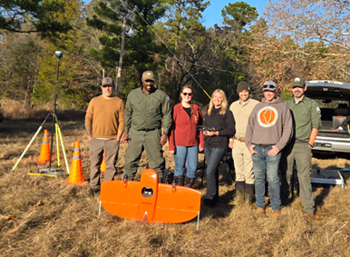
OSMRE staff from Alton, Tulsa, and Pittsburgh pictured with the Wingtra UAS.
The group captured surface data on these sites using aerial LiDAR and high-resolution aerial imagery with the RGB sensors. In addition, a Hydrone bathymetric survey system, coupled with a high-accuracy Global Navigation Satellite System (GNSS) and sonar, was used to survey the underwater terrain of water-filled mine pits, areas currently unmappable with LiDAR alone. This approach ensures full terrain data coverage of both terrestrial and submerged areas. GNSS equipment was also used to survey ground control points, which are used to correct and verify the accuracy of the UAS data.
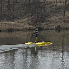
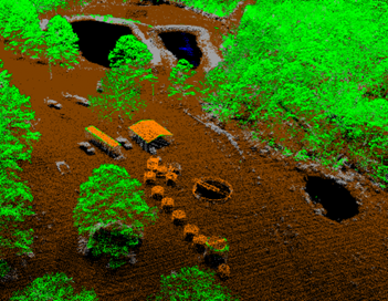
Hydrone in action.
Permit boundaries of the sites covered a combined area of approximately 692 acres. As more drone missions are completed, the speed, safety, and efficiency of UAS-based surveying demonstrates significant advantages over traditional ground-based methods.
Technical Innovation and Professional Services (TIPS) software, including Pix4D and Global Mapper, was used after field data collection to classify LiDAR point clouds, produce high-resolution orthomosaic images, and create digital terrain models and contour maps. These deliverables will be used by Tulsa Field Office technical staff for subsequent design, construction, and maintenance of acid mine drainage passive treatment systems and other mine reclamation activity.
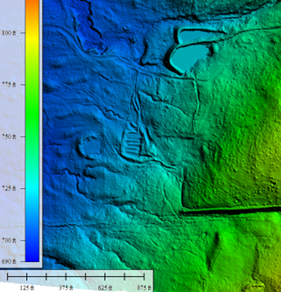
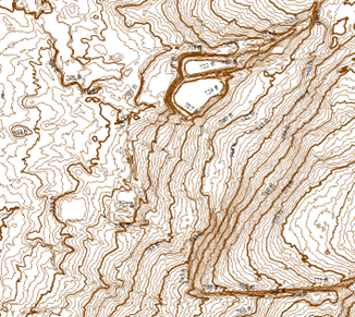
A digital terrain model and contour map as shown in Global Mapper
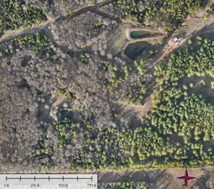
A classified LiDAR point cloud and orthomosaic image as shown in Global Mapper.
Through this effort, three OSMRE UAS pilots also obtained Department of the Interior certification on the new Skydio X10 UAS system. Multiple staff members were cross trained in UAS data collection and bathymetric GNSS surveying. The group created and shared How-To guides so others can adopt these step-by-step processing workflows on future projects. Collaboration with UAS specialists across other Department of the Interior agencies continues as OSMRE shares field and data-processing strategies. Planning is also underway for a SMCRA-wide TIPS UAS workshop in fiscal year 2025.
The rapid improvement of UAS and advanced sensors such as LiDAR, and TIPS software advancements in AI and machine learning make this an exciting time to apply this technology while conducting inspections and fulfilling statutory obligations!